Most of our programs take place at Taylor Park. Click here for information on the Burnstown location.
SkiAbility Ottawa operates on the Rideau River from
Taylor Park at 3230 River Road. The grass lane into the ski area now has a standard green&white blade (3230 number) sign.
and there will be a SkiAbility Ottawa sign present duting program events. Note that this SkiAbility Entrance is NOT the main entrance to Taylor Park.
River Road is also called Regional Road #19 and north of Hunt Club Rad it is Riverside Drive.
The GPS coordinates for the SkiAbility entrance are: 45.135093,-75.632039
| Driving directions to get to Taylor Park | How to find us at Taylor park | Our Burnstown Location |
Driving Directions, via google, to get to Taylor Park:
This Google map allows you to enter your
home address and get step by step directions to the site. Just replace the
start address ( where it says "Place your address here" ) with your own address. Here is the same link in clear text:
http://maps.google.ca/maps?f=d&hl=en&geocode=&saddr=Place+your+address+here&daddr=3230+River+Road,+Osgoode,+ON
Driving Directions to get to Taylor Park -- Text
The following directions should help you determine your method to get to Taylor Park.
From the North West (for example, Kanata) 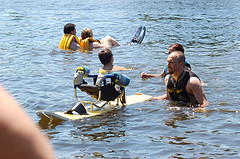 :
:
- Take HWY-417 to Exit 131 for HWY-416 South
- Go South on 416 - 25 km
- Take the HWY-416 exit 49 for Roger Stevens Drive (Reg.Road 6 )
- Turn left at Roger Stevens Dr - go 4.7 km (over the Rideau River)
- At the Stop, turn Right on River Road (Reg.Road 19) heading South
- Proceed south on River Road - go 2.9 km to W.A. Taylor Conservation Area and ...
- Look for the SkiAbility sign marking our special entrance at approx. 3232 River Road
- Turn right on the grass lane to the SkiAbility Area..
- Park anywhere on the grass but be sure to leave room for other for vehicles and trailers
- Refer to map of park below. Anyone can use the "Athlete's entrance".
From the North East (for example, Orleans):![[ Stand up skiing, long line for the first time ]](images/action/PD240.jpg)
- From HWY-417 Wwestbound take exit 117 for Riverside Drive exit 117
- Follow around to Riverside Drive (Reg.Road 19, westbound) - go 12 km
- Continue straight on River Rd (still Reg.Road 19)- go 25 km to W.A. Taylor Conservation Area
- See step 7 above.
From the South (For example Prescott):
- Take the HWY-416 North past Kemptville
- Take exit 40 for Rideau River Road / County Road-19
- Turn right at Rideau River Rd - go 3.1 km
- Continue straight on River Rd (nor Reg.Road 19) - go 3.7km -- About 200 metres after W.A. Taylor Conservation Area at 3240 River Road
- Turn left on the grass lane identified by the SkiAbility sign
- Park anywhere on the grass but be sure to leave room for other for vehicles and trailers
- Refer to map of park below. Anyone can use the "Athlete's entrance".
Maps (for the described routes) will be added soon.
If you are still having trouble with the directions, email us at Info@SkiAbilityOttawa.ca or call (613) 692-4898
Here is a map of Talor Park -- what it looks like when you are flying in.
![[ Map of Taylor Park ]](images/maps/TaylorParkSAOb.jpg)
Our Location in Burnstown:
It has been our habit to hold one clinic per year at the Burnstown site ... primarily for the benefit of clients to the west of Ottawa. It is a beautiful site and, if it were not for the driving distance, we would hold more clinics there.
The Burnstown clinic is held at the Rowing Club dock adjacent to the Burnstown Beach about 1 km East of Burnstown Ontario. This google map will gives driving directions from Arnprior and allow you to obtain driving directions from your home if you replace Arnprior with your home address. The GPS coodinates for the park entrance are: 45° 23.544'N 76° 34.096'W. This entrance will be signed when we are on site.
Once you enter the park follow the gravel road west (same direction as to Burnstown) to the endparking lot, then walk the last 100m to the Rowing Club area. You may NOT park at the Rowing Club.
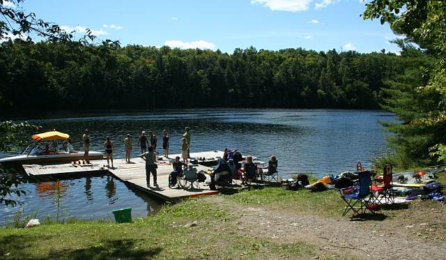
The dock at Burnstown